The Shtrek: Conceptual Trail Construction Plan
The Shtrek: Conceptual Trail Construction Plan Route: Qusayr Amra (Jordan) to Jerusalem (Israel/Palestine) Total Distance: 99 Miles (Exactly) Purpose: Tri-Faith Spiritual Holy Trek Style: Wilderness/Historic Footpath (Appalachian Trail Inspired)
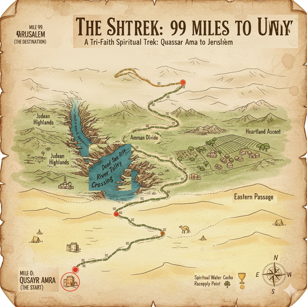
I. Route Segments: Qusayr Amra to Jerusalem (Miles 0-99) The path is divided into three major geographical sections, culminating in the critical final mile.
Segment 1: The Eastern Passage (Miles 0 - 33) This section traverses the eastern desert and semi-arid plateau of Jordan, following ancient paths and the remnants of Roman road systems.
Waypoint/Marker
Mile
Elevation/Terrain Notes
Qusayr Amra (START)
0
Flat, arid desert start. Roman/Umayyad history.
Al-Azraq Shelter
15
First major rest area. Essential water cache access.
Al-Harrana Junction
33
End of the desert plain. Transitioning into rolling hills.
Trail Notes: Exposed to sun and wind. Focus on navigation and water carry capacity. Requires careful placement of emergency water drops (caches) for construction planning.
Segment 2: The Heartland Ascent (Miles 33 - 66) The trail enters the agricultural and hilly terrain west of Amman, characterized by moderate climbs and views of ancient settlements.
Waypoint/Marker
Mile
Elevation/Terrain Notes
Salt Lookout
45
High point with views back east. Rocky terrain, moderate elevation change.
Wadi Shuaib Descent
55
Steep, winding descent into a fertile valley. Potential for flash flooding in spring.
Amman Divide
66
The high western edge of the Jordanian plateau before the dramatic drop.
Trail Notes: Increased rock scrambling. Opportunity for traditional resupply in small towns. Highest average elevation of the entire trek.
Segment 3: The Valley and The Climb (Miles 66 - 98) This is the most physically challenging segment, involving the descent into the Jordan River/Dead Sea Valley and the immediate, steep ascent out of the rift valley towards the Judean Mountains.
Waypoint/Marker
Mile
Elevation/Terrain Notes
Dead Sea Rift Overlook
75
Dramatic view of the rift valley. Start of continuous, steep descent.
The River Crossing
88
Conceptual border crossing point in the valley floor. Low elevation, high heat/humidity.
Ma’ale Adumim Ascent
95
Beginning of the unrelenting, steep climb. Switchbacks essential for safety.
Jerusalem Outskirts
98
The final physical rest stop. Terrain stabilizes as the city comes into sight.
Trail Notes: Extreme elevation differential (descent then ascent). Needs permanent trail infrastructure (steps, hand-holds) for safe passage.
II. The 99th Mile: The Final Commitment (Mile 98 - 99) This segment is the spiritual and symbolic culmination of the ‘Shtrek’.
Waypoint/Marker
Mile
Significance
The Threshold (Mile 98)
98.0
The final physical stopping point. From here, the path is mental and spiritual.
The Last Mile Sign
98.5
A marker signifying that the remaining distance represents The One Thing Everyone Needs to achieve 100% spiritual completeness.
Jerusalem (The Destination)
99.0
Symbolic arrival at the holy site. The physical trek is complete; the spiritual commitment is sealed.
Conceptual Goal: The “Last Mile” challenges the pilgrim to name their final commitment—be it Unity, Empathy, Sacrifice, or Forgiveness—the principle that bridges the final divide.
III. End-to-End Overview The ‘Shtrek’ is a 99-mile path that spans from the desert beginnings of the Umayyad caliphate to the spiritual heart of the Abrahamic faiths. It is defined by its dramatic contrast in environments: from the arid eastern plains, through the central rocky hills, down into the lowest point on earth (the rift valley), and finally the strenuous, symbolic climb into the Judean highlands. The total physical distance is 98 miles, with the 99th mile serving as the essential, non-physical step to complete the pilgrimage.